


This version expands on the original LinkedIn publication, which focused on the Witwatersrand, by incorporating additional information about the geology of all the major gold-mining districts in Southern Africa. You can also read the comments on the original post. This work is AI-assisted—read about how I work.
The gold arc of this series opened two weeks ago with the 1886 discovery at Langlaagte. Last week it covered the six houses that built the industry. This is the geology post, written by someone still working out what it means.
I am a lawyer interpreting a field I have not studied, working from research and from limited conversations with people who have spent careers in it. These geology posts are the hardest ones I write. My first attempt at this register was Two Giant Rock Formations, One PGM Story, posted 19 March. This is my second. Earlier in this series I ran into difficulty with the deep geological survey history at Mingomba in Zambia, a reminder that this is exactly the kind of territory where I can get things wrong. I approach these posts with a measure of anxiety for that reason.
There are geologists and technical experts in this audience, from South Africa to Zambia to Australia, Canada, the USA and beyond. I rely on their frankness. If something here is wrong, simplified beyond usefulness, or missing something that matters, the comments are the place. A layman’s view is all I can offer. What makes posts like this work is the people who know better saying so.
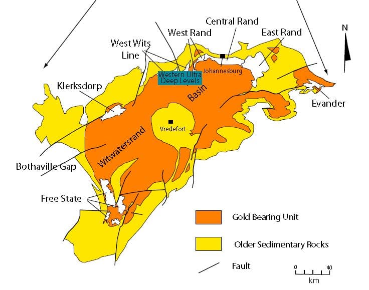
One sedimentary basin in southern Africa has produced approximately one-third of all gold ever mined on Earth. The Witwatersrand is 350 kilometres long. From reefs that average less than two metres thick. Roughly 50,000 metric tonnes in total. No other geological structure is close.
The first thing that surprised me: the gold is not igneous. It did not come from magma or from heat below. Between 2.9 and 2.7 billion years ago, rivers eroded gold-bearing highlands, highlands that no longer exist, and deposited the load in gravel bars. Heavy material sinks. The gold settled. Those bars are now stone. Compressed riverbeds, tilted sideways, buried deep. Every digger who arrived from California or Victoria had learnt to follow the vein. There was no comparable vein here.
But there was a precondition. Around 2.0 billion years ago, an asteroid approximately 20 kilometres across struck the earth 120 kilometres southwest of what is now Johannesburg. The largest confirmed impact structure on earth. The force folded and lifted the basin rim, bringing buried reef edges back toward the surface. The prospectors at Langlaagte in 1886 were walking on ground the asteroid had prepared. Without it, the reefs stay flat and deep. The starting point is the impact.
From that starting point, the reef dips inward. Following it means going down. The Carbon Leader Reef, roughly a metre thick, up to 12.6 g/t in the West Wits fields, runs for hundreds of kilometres into the earth. The Ventersdorp Contact Reef at Mponeng averages 78 centimetres across its channel. Narrower than a human shoulder span. Both require following them deeper.
At Mponeng today the working face sits between 3.16 and 3.74 kilometres below surface. Rock temperature exceeds 60 degrees Celsius before refrigeration. That is not an operating choice. It is what the reef requires. The R7.9 billion extension project now underway will take Mponeng to 4.2 kilometres. The deepest mine in human history will go deeper still.
Not every South African gold story reaches that scale. #MiningIsHuman started in November last year with an odd one: a gold discovery on Lion’s Head in Cape Town in November 1887. A syndicate struck traces of gold in pyrite veins, sank a 45-metre shaft, then found nothing worth mining. Not quite a scam. More a genuine discovery that the geology refused to confirm.
In 1876, James Hooper found alluvial gold in the Karatara River in the Knysna forest, reportedly while searching for grit for his ostriches. A town appeared briefly, with hotels and a newspaper. Total recorded production: 3,170 ounces. The Witwatersrand proclamation in 1886 drew the prospectors away before Millwood had properly started. Mine ruins at Jubilee Creek are preserved by SANParks today.
Between Lion’s Head and Millwood and the Witwatersrand, the distance is at least 1,000 kilometres, and about as large a gap in geological significance as exists anywhere on Earth. One failed to prove up. One was real but small. One changed the world. All human, all worth a mention. Gold fever in southern Africa ran ahead of the geology more often than the textbooks suggest.
Gold appears in other geological systems across the region too. Barberton’s greenstone belt at 3.5 billion years old. Zimbabwe’s craton with more than 4,000 recorded deposits. Tanzania’s Lake Victoria goldfields. Kibali in the northeast Congo. Otjikoto in Namibia’s Damara Belt. Different formations, different ages, different mining traditions.
The Witwatersrand is the dominant one. What makes it dominant is not just the gold already taken. At least half the basin’s gold is estimated to remain, at depth, unreached. It is how far down the reef goes, and the fact that people have kept following it.
That is the dominant system. It is not the only one. Six geological systems put gold into the ground across this region, and each one got there a completely different way.
Barberton produced gold before anyone had heard of the Witwatersrand. The rush there started in 1884, prospectors following alluvial colour upstream into the Sheba Hills, finding reef gold in ancient volcanic rock. A town appeared almost overnight. The De Kaap valley filled with diggers. For two years, Barberton was the centre of South African gold.
Then the Witwatersrand was found. Barberton didn’t disappear. Fairview and Sheba mines operated through the twentieth century and still produce today. But it was eclipsed so completely that most people don’t know it came first.
The Barberton Greenstone Belt is 3.5 billion years old, the oldest intact surface geology on Earth. The gold sat there long before the Witwatersrand basin existed.
Zimbabwe has more than 4,000 recorded gold deposits. Not mines, deposits. Across more than two dozen greenstone belts running from Bulawayo to Harare and beyond. Most have been worked in some form since pre-colonial times, and pre-colonial here means a very long time.
The Great Zimbabwe civilisation, at its peak between 1100 and 1450 AD, built its wealth on gold. Not on mining at industrial scale, but on controlling the trade routes that moved gold from the plateau to the coast. The port of Sofala, in present-day Mozambique, was the conduit. From Sofala, gold moved north to Kilwa Kisiwani in Tanzania, one of the great Swahili trading cities, described by the Moroccan scholar Ibn Battuta in 1331 as among the most beautiful in the world. From Kilwa it entered the Indian Ocean economy. Zimbabwe’s gold reached Arab, Persian, and Indian markets before a single European prospector arrived.
The colonial rushes followed the same ancient workings. Blanket Mine in Gwanda has operated since 1904. Caledonia Mining still runs it today.
The geology that put gold there 2.7 billion years ago has outlasted every political arrangement placed above it.
Tanzania’s gold is the same age as Zimbabwe’s but sits in completely different rock. In the Lake Victoria goldfields, the gold is not in volcanic shear zones. It is in banded iron-formation, ancient seafloor sediment, layers of iron-rich rock laid down before complex life existed, later cracked by tectonic movement. Gold settled into those cracks. A different trap, in the same ancient era.
The result is a different kind of mine. Geita, on the southern shore of Lake Victoria, is operated by AngloGold Ashanti and produces over 500,000 ounces a year. North Mara and Bulyanhulu mine the same system further east. Tanzania holds over 60 million ounces in identified reserves. The fields are far from finished.
The system does not stop at the Tanzanian border. The same greenstone belts extend into Kenya and Uganda. Shanta Gold’s West Kenya project, an hour from Kisumu, completed its feasibility study in 2025 and has commenced project financing, $510 million committed. The geology crossed the border long before the border existed.
The DRC carries two gold systems with almost nothing in common.
The Kilo-Moto goldfields in the northeast have produced gold since 1903, when prospectors found colour in the Ituri River. The geology is Congo Craton greenstone, the same ancient volcanic rock as Barberton and Zimbabwe, with some gold in conglomerate layers that faintly echo the Witwatersrand mechanism. Kibali is the formalised version of that history. Opened in 2013, owned 45% by Barrick, 45% by AngloGold Ashanti, and 10% by SOKIMO for the Congolese state. For most of its history Africa’s largest gold producer: 673,000 ounces in 2025, 99.6% of DRC’s formal gold exports. It has contributed over $6.3 billion to the Congolese economy since opening.
Twangiza-Namoya is something else. A 210-kilometre belt in South Kivu and Maniema, formed about a billion years ago when two ancient landmasses collided, heating the rock and driving fluids upward into quartz veins. A fifth geological system. Nothing else in this arc replicates it. Measured and indicated resources across the belt exceeded 7 million ounces at peak.
Twangiza is currently occupied by rebels. The geology has not changed. The gold is still there.
Namibia’s gold is the youngest in this arc, and the most different from everything else in it.
The Damara Belt formed about 550 million years ago when three ancient cratons collided and crumpled the rock between them. The heat and pressure that followed pushed fluids through the rock, and those fluids left gold behind, in marble, in schist, in quartz veins. It is the same basic idea as Barberton’s shear zones, but the rock is completely different, and the event that caused it happened more than two billion years later.
Nothing else in this arc works the same way. The Witwatersrand is river gravel turned to stone. Barberton and Zimbabwe are ancient volcanic rock cracked by pressure. Tanzania is old seafloor. The DRC carries two systems: Congo Craton greenstone at Kibali, and hydrothermal veins in younger rock at Twangiza. Namibia is none of those. It is a collision belt, half a billion years old, that has more in common with gold deposits in Europe than with the mines to its east.
The deposits are modest. But as a sixth geological system, it completes the picture. That is the whistle-stop tour of the major gold geological systems of southern and eastern Africa: six different ways the same element ended up in the ground.
One more number, to close. Southern Africa holds around 8 to 10% of the world’s identified gold reserves. Meaningful. Not the dominant number.
The same region holds around 70% of the world’s manganese, 90% of its platinum group metals, 75% of its chrome, and significant shares of vanadium, cobalt, uranium, fluorspar, zinc, copper, lithium and antimony. Gold is not the headline mineral story of southern Africa. It never was.
But gold and diamonds captured the global imagination, and that capture proved durable. It shaped the investment narrative, the colonial architecture, the infrastructure corridors, and the city that grew up above the Witwatersrand reef. Popular sentiment follows the stories it was first told.
Southern Africa’s mineral wealth is not gold. But if gold is the frame the world insists on, it still holds more than most people know. Six systems. Three billion years of range between the oldest and the youngest. And a basin that, a hundred and forty years on, is still not finished giving it up.